420-421
| Previous Page | Next Page |

|
rise in a line parallel with the southwest shore. The Ewa Divide lies 5 miles west of Honolulu. This Ewa Plain is nearly 20 miles in length from Pearl River to Waialua, and in some parts is 9 or 10 miles across; its soil is fertile, and watered by a number of rivulets running along deep water courses emptying into the sea.
Plain of Honolulu.—This plain is some 10 miles in length, and in some parts 2 miles in width from the sea to the foot of the mountains.
The whole plain is covered with rich, alluvial soils, in places 2 or 3 feet deep. Under this lie volcanic ashes and cinders 14 to 16 feet deep, resting on a stratum of solid nonvolcanic rock, a kind of sediment deposited by the sea, in which branches of white coral, bones of fish and animals, and several varieties of marine shells have been found. A number of wells have been dug to a depth of 12 to 13 feet in the substratum of rock, always reaching good clear water, which, though free from salt or brackish taste, rises and falls with the tide.
Inland from Waikiki, near Honolulu, and reached by the Punahou road, lies the Manoa Valley, whose upper portion divides into numerous canyons.
There is a broad valley called Nuuanu, bounded by a mountain wall 20 miles in length, which rises from the green, rolling plain below.
Less than 5 miles from Honolulu, in a westerly direction, lies the valley of Moaualua. Here are line rice fields, cocoanut groves, and fish ponds.
In the district of Waianae the bases of the mountain lie farther from the sea and a narrow valley, presenting a fertile and cultivated aspect, seems to wind for some distance through hills.
In the Waialua bay district the soil is sandy and poor, but a short distance inshore an agreeable change takes place.
CITIES, TOWNS, AND PORTS, OAHU.
Honolulu.
Honolulu is the capital and principal port of the Hawaiian Islands, and is situated on the south side of Oahu, on a narrow plain at the foot of the eastern range of mountains.
The aspect of the country around Honolulu, as seen from the roads, is barren; and the plain on which the town stands is destitute of verdure. This plain extends east and west from the town, while behind it the laud rises gradually towards the Nuuanu Valley. Several crater-shaped hills are in sight, one of which, named Punch Bowl Hill, 498 feet high, lies close to the northeast side of the town.
The central part of Honolulu consists of regularly laid out streets, on either side of which stand houses and warehouses of European style, frequently placed within spacious, inclosed gardens. The outer portions of the town are chieliy composed of grass huts inhabited by natives. Honolulu would, probably, burn easily to the ground.
Amongst the principal buildings are the spacious Government houses, in which all the public offices are inclosed, the King's palace, a fort, two hospitals, several churches and chapels belonging to the different religious denominations, custom house, sailors' home, and several schools.
Hospitals.—There is a quarantine hospital on the west side of the harbor, and a good general hospital to which sailors and others are admitted at $1.25 per diem.
Shops.—There are foundries, workshops, and shipyards, where considerable repairs can be effected.
|
Patent slip.— A patent slip has been constructed by the Government on the east side of the harbor opposite the outer light house. This slip can take a vessel of 1,700 tons.
The harbor is formed by an opening in the coral reef, about 150 yards wide at the entrance and 300 yards wide off the town, and rather more than a mile in length. Though small it is capable of accommodating a good number of vessels. Depth on bar is 30 feet.
Wharves.—The railway crosses the flats on the north side of the harbor and terminates at two wharves, with 19 feet of water alongside each of them. The west wharf is used by ships.
There is in the harbor altogether 1,900 feet of wharf frontage, with a depth of 211/2 feet, and 700 feet with depths of from 17 to 19 feet, and about 1,200 feet with less depth.
Tides.—The tidal streams are regular, running six hours each way. The flood is to the westward. Springs rise from 21/2 to 3 feet.
Supplies.—Supplies of all kinds are plentiful. Beef, mutton, fowls, eggs, vegetables, and fruit can be obtained at moderate prices.
Water can be procured from the shore in a tank. It is good, but very expensive, even in the inner anchorage being $2.50 a ton. This for ships.
Implements and building materials (with the exception of timber, which is good and moderate in price) are excessively costly in Honolulu. The demand for and sale of articles required for the equipment of ships have greatly diminished.
Probably material for repair of arms, equipments, and munitions of troops could be obtained with difficulty, or not at all.
Water and lighting.—Honolulu has an abundant supply of excellent water—pure, free from limestone or alkali, soft, and adapted to all the uses of the city. It is brought from reservoirs at the upper end of the lovely Nuuanu Valley, and conveyed by pipes through the business and principal residence districts. The city is lighted by electricity, the power for the generation of which is derived from the reservoirs referred to. Both the water and lighting systems are controlled by the Government.
Coal.—Welsh or Australian coal of good quality can be obtained from European firms. About 15,000 tons is the quantity generally kept in stock.
Climate.—The climate of Honolulu is generally very pleasant and healthful, especially when the northeast trade wind prevails. The southerly and southwesterly winds are called by the natives the "sick winds," because they are followed by small ailments, gastric maladies, and intermittent fevers, as is the case with the sirocco in Europe.
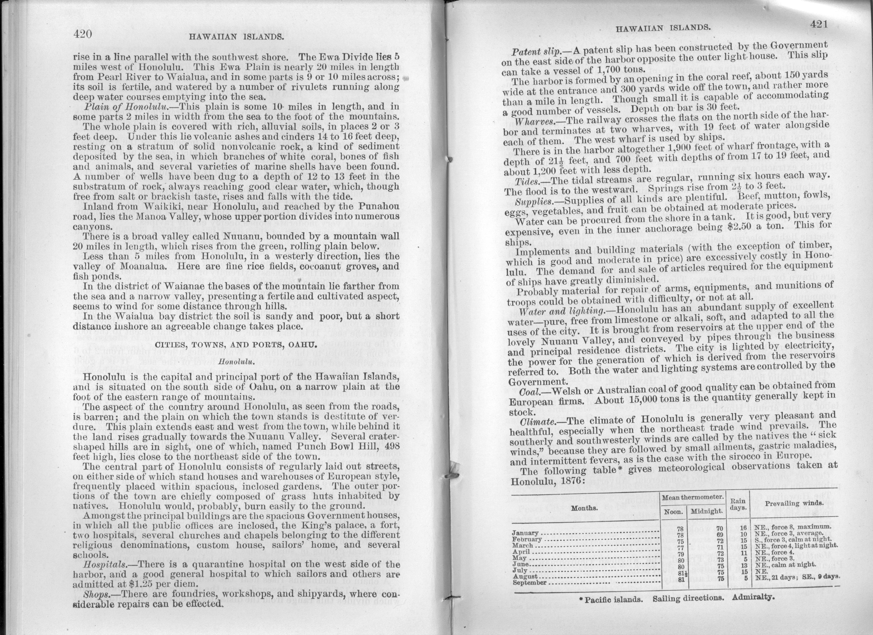
The following table* gives meteorological observations taken at Honolulu, 1876:
| Months | Mean thermometer. | Rain days. | Prevailing winds. | |
| Noon. | Midnight | |||
| January | 78 | 70 | 16 | NE., force 8 maximum. |
| February | 78 | 69 | 10 | NE., force 3, average. |
| March | 75 | 72 | 15 | S., force 3, calm at night. |
| April | 77 | 71 | 15 | NE., force 4, light at night. |
| May | 79 | 72 | 11 | NE., force 4. |
| June | 80 | 73 | 5 | NE., force 3. |
| July | 80 | 75 | 13 | NE., calm at night. |
| August | 811/2 | 75 | 15 | NE. |
| September | 81 | 75 | 5 | NE., 21 days; SE., 9 days. |
* Pacific islands. Sailing directions. Admiralty.
| Previous Page | Next Page |